


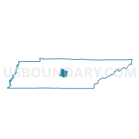
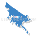
03-3 Wilson Elementary School Voting District, Rutherford County, Tennessee
About
Outline

Summary
| Unique Area Identifier | 669485 |
| Name | 03-3 Wilson Elementary School Voting District |
| County | Rutherford County |
| State | Tennessee |
| Area (square miles) | 31.15 |
| Land Area (square miles) | 27.30 |
| Water Area (square miles) | 3.86 |
| % of Land Area | 87.62 |
| % of Water Area | 12.38 |
| Latitude of the Internal Point | 36.03217750 |
| Longtitude of the Internal Point | -86.43980900 |
Maps


Graphs
Select a template below for downloading or customizing gragh for 03-3 Wilson Elementary School Voting District, Rutherford County, Tennessee


Neighbors
Neighoring Voting District (by Name) Neighboring Voting District on the Map
- 01-2 Roy Waldron School Voting District, Rutherford County, TN
- 02-2 Walter Hill School Voting District, Rutherford County, TN
- 03-1 Leana Community Center Voting District, Rutherford County, TN
- 03-2 Nissan Activity Center Voting District, Rutherford County, TN
- 12 Cedars of Leb. St. Park Assembly Hall Voting District, Wilson County, TN
- 12-1 Tennessee Rehab Center Voting District, Rutherford County, TN
- 13 Gladeville Elementary Voting District, Wilson County, TN
- 33-1 Eagle Christian Church Voting District, Davidson County, TN
Top 10 Neighboring County Subdivision (by Population) Neighboring County Subdivision on the Map
- District 33, Davidson County, TN (22,299)
- District 1, Rutherford County, TN (16,650)
- District 2, Rutherford County, TN (12,397)
- District 3, Rutherford County, TN (12,027)
- District 12, Rutherford County, TN (11,505)
- District 13, Wilson County, TN (4,565)
- District 12, Wilson County, TN (4,181)
Top 10 Neighboring Place (by Population) Neighboring Place on the Map
- Nashville-Davidson metropolitan government (balance), TN (601,222)
- Smyrna town, TN (39,974)
- La Vergne city, TN (32,588)
- Rural Hill CDP, TN (2,007)
- Walterhill CDP, TN (401)
Top 10 Neighboring Unified School District (by Population) Neighboring Unified School District on the Map
- Nashville-Davidson County School District, TN (626,681)
- Rutherford County School District, TN (153,649)
- Wilson County School District, TN (84,298)
Top 10 Neighboring State Legislative District Lower Chamber (by Population) Neighboring State Legislative District Lower Chamber on the Map
- State House District 34, TN (101,480)
- State House District 57, TN (84,276)
- State House District 49, TN (81,804)
- State House District 60, TN (75,644)
- State House District 46, TN (68,934)
Top 10 Neighboring State Legislative District Upper Chamber (by Population) Neighboring State Legislative District Upper Chamber on the Map
- State Senate District 16, TN (231,510)
- State Senate District 17, TN (208,424)
- State Senate District 20, TN (194,112)
Top 10 Neighboring 111th Congressional District (by Population) Neighboring 111th Congressional District on the Map
Top 10 Neighboring Census Tract (by Population) Neighboring Census Tract on the Map
- Census Tract 309.01, Wilson County, TN (9,572)
- Census Tract 156.31, Davidson County, TN (8,758)
- Census Tract 404.03, Rutherford County, TN (7,353)
- Census Tract 405.01, Rutherford County, TN (6,989)
- Census Tract 405.02, Rutherford County, TN (6,609)
- Census Tract 410, Rutherford County, TN (6,500)
- Census Tract 309.03, Wilson County, TN (6,081)
- Census Tract 422, Rutherford County, TN (5,002)
- Census Tract 309.04, Wilson County, TN (3,523)
- Census Tract 401.01, Rutherford County, TN (3,253)
Top 10 Neighboring 5-Digit ZIP Code Tabulation Area (by Population) Neighboring 5-Digit ZIP Code Tabulation Area on the Map
- 37130, TN (52,070)
- 37167, TN (49,322)
- 37129, TN (49,103)
- 37122, TN (46,463)
- 37076, TN (35,230)
- 37086, TN (31,513)
- 37090, TN (12,922)